Pre-1980 Altadena and Pacific Palisades housing burned. SCAQMD runs five air sites. No agency tests the parcels.
Pre-1980 housing in the Eaton and Palisades burn zones contained asbestos. SCAQMD runs a 5-site air-monitoring network. No agency tests parcels.
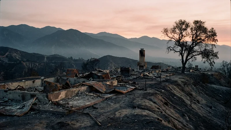
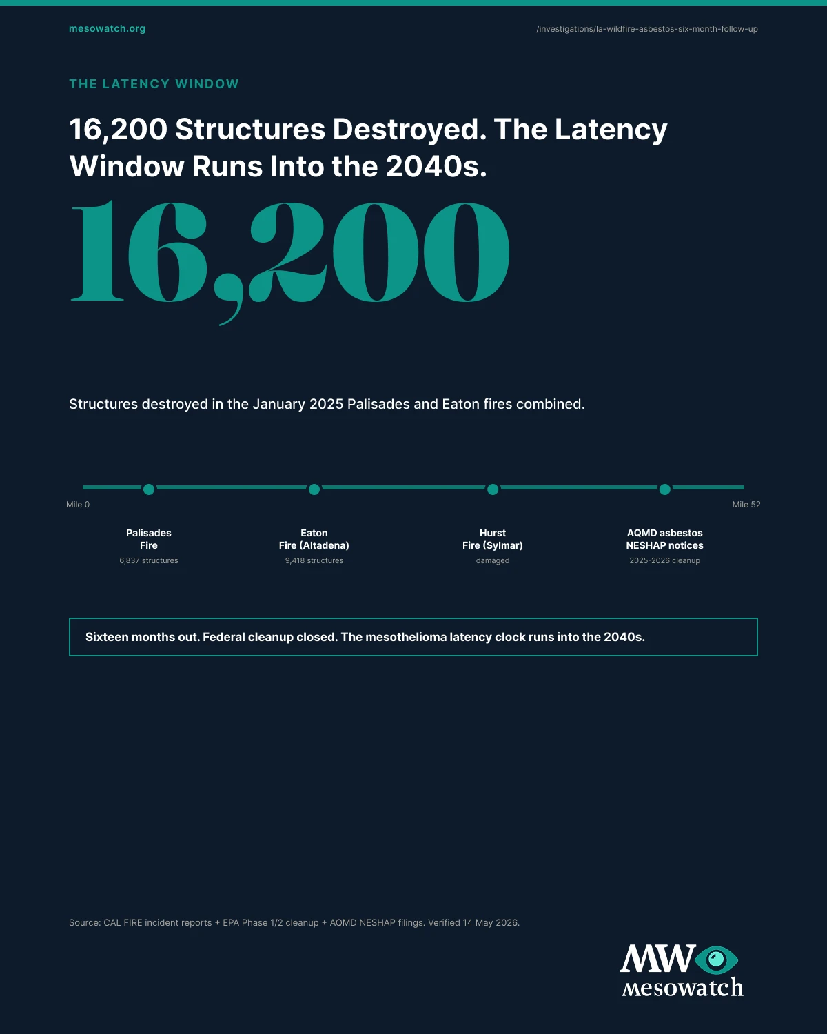
Pre-1980 housing in Altadena and Pacific Palisades contained asbestos. When 16,200 structures burned in January 2025, that material entered ash, debris, and airborne particulate. This is what the public monitoring record shows about that exposure, and where it stops.
The South Coast Air Quality Management District has operated a 2025 Wildfire Air Monitoring network since the spring after the fires: three ambient sampling sites in the Eaton burn area, two in the Palisades area. It collects 24-hour air samples roughly every three days and publishes detailed per-sample result tables, with quality-assurance notes that flag individual samples invalid on specific dates. The portal is public.
That community-level ambient record is the spine of what is knowable about airborne asbestos in the burn zones. It is not a per-parcel record. EPA Phase 1 and USACE Phase 2 handled asbestos-containing material under removal protocols, but no agency has published a final per-parcel quantitative asbestos result for the roughly 13,900 impacted properties. So the accurate framing is a real community ambient dataset plus a genuine per-property data gap, with cleanup figures the prior version of this report got wrong and that are now quoted from EPA, Cal OES, USACE, and LA County instead.
The Monitoring Record That Exists
SCAQMD’s network is the primary airborne-asbestos record for these burn zones, and it is the spine of this report because it is verifiable and was missed. Three Eaton sites, two Palisades sites, 24-hour samples on a roughly three-day cadence, with per-sample tables and explicit invalid-sample flags.
This report deliberately does not state how many samples exceeded any threshold, or whether the network shows the community safe or unsafe. The portal exposes the sample tables but no single headline exceedance figure, and computing or asserting one without working directly from those tables would repeat the exact failure mode being corrected here.
The defensible primary statement is narrow and still significant: the dataset exists, it is structured for time-series ambient analysis, and the previous version of this article was wrong to tell readers it did not. What SCAQMD’s ambient network does not do is test each burned parcel. That is the real gap.
The Per-Property Gap
Ambient monitoring and per-property testing are different instruments, and only one of them exists for these fires. EPA Phase 1 and USACE Phase 2 handled asbestos-containing material under removal protocols, but no agency published a final per-parcel quantitative asbestos result for the roughly 13,900 impacted properties.
So the accurate framing is a real community ambient record plus an absent per-parcel record, not the total data void the prior version implied. Naming that distinction precisely is the difference between an honest limitation and a false absence.
The Cleanup Figures, Corrected
Almost every load-bearing cleanup number in the prior version was wrong or unsourced. Here they are, quoted from the primary agency releases.
Per EPA’s February 2025 reporting, about 13,595 residential and 305 commercial properties were impacted. Roughly 12,024 were surveyed in Phase 1 (about 6,506 in Eaton, 5,518 in Palisades), and about 7,100 were cleared on an interim basis at the 75% milestone, with about 3,475 deferred into Phase 2. EPA reported more than 1,700 staff on the response and finished Phase 1 about 29 days after field work began.
The prior version said EPA cleared more than 1,600 properties. That figure was a misreading of the 1,700-plus staff number. It is removed.
For Phase 2, California’s Office of Emergency Services reported more than 5,000 properties with final sign-off as of May 2025. USACE later described the mission retrospectively as more than 9,500 properties and about 2.6 million tons of debris, with private debris removal completing in early September 2025. LA County recovery reporting places Phase 2 completion in September 2025.
The prior version said the work finished in August 2025 and that the Palisades total reached 4,011 properties. No primary source publishes either. Both are removed.
Why the Housing Era and the Latency Window Are Context, Not the Headline
Both Altadena and Pacific Palisades carry substantial pre-1980 housing, and pre-1980 residential construction used asbestos as standard practice: thermal pipe insulation, vinyl asbestos floor tile, asbestos cement siding and roofing, sprayed acoustic popcorn ceilings, and transite vent pipe. When that stock burns, the material is disturbed into ash, debris, and airborne particulate. That is the exposure pathway SCAQMD’s network is positioned to observe at the community level.
The 20-to-50-year mesothelioma latency from ATSDR is the mechanism, not a finding. It is true of every asbestos exposure event and is date arithmetic on a known ignition date. The prior version elevated a latency window that will not close until the 2040s to a headline. It is demoted here to what it is: the reason the monitoring record matters at the moment of exposure, because any disease signal will not appear in the California Cancer Registry for decades.
A Closing Thesis
For an Altadena or Pacific Palisades family asking what asbestos exposure looks like after the fires, the answer is two distinct records and a clear gap between them.
There is a real community ambient monitoring record that SCAQMD has been publishing since March 2025 at five sites on a three-day cadence, with per-sample tables and explicit invalid-sample flags. There is a real per-parcel data gap that no agency has filled across the roughly 13,900 impacted properties. The cleanup figures are now quoted from EPA, Cal OES, USACE, and LA County rather than from the prior version of this report, which had several wrong. And there is a 20-to-50-year mesothelioma latency window that means any disease signal attributable to these fires will not appear in the California Cancer Registry until the 2040s, which is the reason the monitoring record matters now, when the exposure happens, not decades later when disease would appear.
The EPA chrysotile rule and Texas military base investigations apply the same discipline elsewhere: the finding is whatever the primary record actually supports, the gaps are stated as gaps, and a community asbestos story is reported from the agency record, not from inference.
Reader Q&A
Frequently Asked Questions
Is there any public airborne-asbestos monitoring data for the LA burn zones?
Yes. The South Coast Air Quality Management District operates a 2025 Wildfire Air Monitoring program with three sites in the Eaton burn area and two in the Palisades burn area. It collects 24-hour ambient air samples roughly every three days and publishes detailed per-sample result tables, including documented quality-assurance flags marking individual samples invalid on specific dates. The program portal is public. An earlier version of this MesoWatch report stated that no quantitative asbestos monitoring data was published, which was incorrect; this report corrects that and points readers to the SCAQMD portal as the primary source rather than summarizing a pass or fail conclusion it has not independently computed.
What is the per-property testing gap, then?
Ambient monitoring and per-property testing are different things. SCAQMD's network measures airborne fiber concentrations at fixed community locations over time. It does not test each individual burned parcel for asbestos. EPA Phase 1 and USACE Phase 2 removed hazardous materials and debris under protocols that handle asbestos-containing material, but no agency published a final per-property quantitative asbestos result for the roughly 13,900 impacted properties. So the honest picture is a real community ambient dataset plus a genuine per-parcel data gap, not the total absence of data the prior version implied.
How big were the Eaton and Palisades Fires?
Both ignited on January 7, 2025 in Los Angeles County. Per Cal Fire incident reporting, the Eaton Fire burned about 14,021 acres in the Altadena and Pasadena area and destroyed approximately 9,400 structures. The Palisades Fire burned about 23,448 acres and destroyed roughly 6,800 structures. Combined, approximately 16,200 structures were destroyed. Much of the destroyed stock in both Altadena and Pacific Palisades was pre-1980 housing built when asbestos-containing materials were standard in residential construction.
What did EPA Phase 1 actually do, and how many properties?
EPA Phase 1 handled household hazardous materials and visible or easily identifiable asbestos and propane tanks. Per EPA's February 2025 reporting, about 13,595 residential and 305 commercial properties were impacted; roughly 12,024 were surveyed (about 6,506 in Eaton and 5,518 in Palisades) and about 7,100 cleared on an interim basis as of the 75% milestone, with about 3,475 deferred into Phase 2. EPA reported more than 1,700 staff on the response and completed Phase 1 about 29 days after field work began. An earlier version of this report stated EPA cleared 'more than 1,600 properties'; that number was a misreading of the staff figure and has been removed.
What did USACE Phase 2 do, and when did it finish?
USACE Phase 2 removed ash, structural remains, hazardous materials, foundations, asbestos-containing materials, and a layer of soil, for property owners who granted Right of Entry. California's Office of Emergency Services reported more than 5,000 properties with final sign-off as of May 2025. USACE later described the mission retrospectively as more than 9,500 properties and about 2.6 million tons of debris, with private debris removal completing in early September 2025. LA County recovery reporting puts Phase 2 completion in September 2025. A prior version of this report said August 2025 and stated a Palisades subtotal of 4,011 that no primary source publishes; both were corrected or removed.
Why does the housing era matter?
Pacific Palisades and Altadena both have substantial pre-1980 housing. From roughly 1930 to 1980, asbestos-containing materials were standard in residential construction: thermal pipe insulation, vinyl asbestos floor tile, asbestos cement siding and roofing, sprayed acoustic popcorn ceilings, and transite vent pipe. When pre-1980 structures burn, those materials are disturbed and can enter ash, debris, and airborne particulate, which is the exposure pathway the SCAQMD ambient network is positioned to observe at the community level.
What is the cancer-latency context?
Pleural mesothelioma latency from initial asbestos fiber inhalation typically runs 20 to 50 years per ATSDR. This is the mechanism, not a finding: it means any mesothelioma signal attributable to these fires would not surface in the California Cancer Registry until the 2040s, so near-term surveillance necessarily focuses on acute respiratory effects rather than mesothelioma incidence. The latency window is context for why the monitoring record matters now, when the exposure happens, not decades later when disease would appear.
What should residents and cleanup workers know?
The OSHA general industry asbestos standard (29 CFR 1910.1001) sets a permissible exposure limit of 0.1 fiber per cubic centimeter as an 8-hour time-weighted average. Cleanup workers and homeowners performing self-help work should follow OSHA-compliant controls: respiratory protection, wet methods to suppress dust, and proper asbestos-waste disposal. California asbestos personal-injury claims are governed by the asbestos-specific limitations rule at Code of Civil Procedure Section 340.2, which runs from discovery of disability and its asbestos connection rather than from the date of exposure. Residents near burn zones should follow LA County Public Health guidance on indoor cleaning and air quality.
The full asbestos after the la wildfires report, in one image.
Every claim sources to a primary government regulator or named investigative outlet. The composite is free to embed with credit. No modification of the image.
Press inquiries: [email protected] (Claire Brennan)
Want to reach the desk, request the dataset, or subscribe to data drops? Jump to the newsroom